20 Years of Mars Express Images Helped Build This Mosaic of the Red Planet
The Mars Express orbiter, the European Space Agency’s (ESA) first interplanetary mission, entered orbit around Mars on June 2nd, 2003. Since then, the probe has mapped the Martian surface using its High-Resolution Stereo Camera (HRSC), an instrument built by the German Aerospace Center (DLR) with commercial partners. In honor of the mission’s 20th anniversary, a celebration occurred last Friday (June 2nd) at the ESA’s European Space Operations Center (ESOC) in Darmstadt, Germany.
During the festivities, a series of global color mosaic images were live-streamed from the Mars Express orbiter to Earth. The mosaic is the result of a high-altitude campaign conducted by the HRSC science team and state-of-the-art image processing. The result is a mosaic unparalleled in detail, spatial resolution, and diversity of color that provides valuable insight into the Martian environment. This includes revealing the surface composition, demonstrating how water once flowed there in the past, and modern meteorological phenomena.
For almost twenty years, the HRSC mapped close to the entire surface of Mars in color and three dimensions with unprecedented resolution. This is possible thanks to the camera’s four color channels (red, green, blue, and infrared) and five panchromatic nadir, stereo, and photometric channels. The camera, operated by DLR Institute of Planetary Research, was originally to last only one Martian year (about 687 Earth days). But the mission’s success prompted the ESA to extend the mission repeatedly, most recently until the end of 2026.

Credit: ESA/DLR/FU Berlin (G. Michael)
The high-altitude images were planned and acquired by the HRSC team at the Deutsches Zentrum für Luft- und Raumfahrt (DLR) – the German Aerospace Center – in Berlin. The development of the color model and the processing of the mosaic were performed by Dr. Greg Michael, an astrophysicist and radioastronomer at Freie Universität Berlin and the Co-Investigator of the HRSC. A scientific paper from the HRSC team will be published in the near future, along with the georeferenced dataset provided through the ESA guest storage facility.
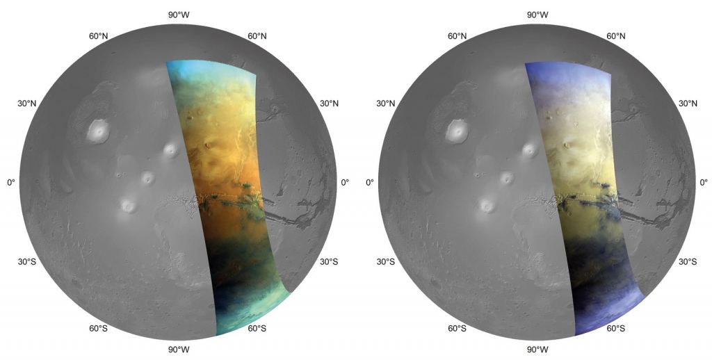
Since it was commissioned in January 2004, the HRSC has imaged almost the entire planet at resolutions of 50 to 20 m (164 to 65.6 ft) per pixel. Normally, the mission would photograph Mars from an altitude of about 300 km (186 mi) when the spacecraft is closest in its orbit to the planet. However, for the mosaic, 90 individual images taken from altitudes of 4,000 to 10,000 km (2485.5 to 6215 mi) were used, covering an area roughly 2500 km (1550 mi) in diameter and with a spatial resolution of 2 km (1.2 mi) per pixel. Many areas in the mosaic appear at the instrument’s highest possible resolution of 12.5 m per pixel.
Another impressive feature is the level of color captured in the images. Ordinarily, it is very difficult to take pictures of Mars that accurately capture its surface color because of the ever-changing transparency of its atmosphere. This is caused by the varying degrees of dust in the atmosphere, which causes light to be scattered and reflected, leading to color shifts between images. To suppress this effect, space agencies often employ image processing that causes color variations to diminish over greater distances.
This time, a new high-altitude observation campaign was used to construct a global color model, which the HRSC team used to color-reference each image in the mosaic. This allowed for long-range color variations and resulted in a picture of Mars with a level of color diversity never seen before. The color variations also reveal information about its composition, which includes the high amount of oxidized iron in its surface regolith. This is what earned Mars the moniker, the “Red Planet,” but observations have also shown that it has dark areas that appear blue, grey, and black.
These regions correspond to volcanic sands that have formed large, dark sand layers that astronomers have observed for centuries. These sands were primarily piled up by the wind to form fields of barchan dunes, which consist of unweathered basaltic minerals (similar to volcanic sands and wind-blown dunes found on Earth). There are also patches of lighter volcanic sands that were weathered over time by water, which once flowed on the surface of Mars (ca. 3 to 2 billion years ago). This has been studied by the Curiosity and Perseverance rovers in the form of clay deposits in the Gale and Jezero craters (respectively).
Clays and sulfate minerals, the two most common-found minerals on Mars, are relatively easy to spot in color composite images because they are particularly bright. For example, large deposits of calcium sulfate (gypsum) and magnesium sulfate (kieserite) can be seen within the Valles Marineris canyon system along the equator (see below). These minerals are covered by a thin veneer of darker sand but are visible thanks to the color variations revealed by the HRSC. The clays and sulfates on the surface are one of many lines of evidence attesting to the planet’s watery past.
The depths of Valles Marineris are overlaid with atmospheric phenomena, such as the faint clouds indicated by the bright white patch on the lower left-hand side. There’s also the hazy fog layer within Valles Marineris, which typically forms within the canyon during certain times of the day and year. Similar fog layers have been observed in depressions and other low-lying areas, like Argyre and Hellas Basin in the Southern Highlands, and in cratered areas across the Northern Lowlands (like the Isidis and Utopia Basin).

The success of the HRSC was a major factor in the decision to prolong the Mars Express mission, which has remained in operation around Mars for 19 years, five months, and 12 days (as of this article’s publication). As of October 19th, 2023, the mission will have completed 25,000 elliptical orbits of Mars, making it the second longest continually active spacecraft, behind NASA’s 2001 Mars Odyssey – also still active around the Red Planet.
Further Reading: DLR
The post 20 Years of Mars Express Images Helped Build This Mosaic of the Red Planet appeared first on Universe Today.